If you’re looking for a map of Cádiz, you’re in the right place. This detailed Cádiz tourist map from the Cádiz tourist board shows the historic centre, main attractions, beaches, transport links and other useful visitor information. Download the free PDF before you arrive and keep it on your phone for an easy overview of the city while you explore.
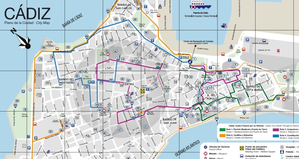
The downloadable map gives you a clear overview of Cádiz’s historic centre and its main neighbourhoods, including El Pópulo and La Viña. It also highlights attractions such as the Cathedral, Tavira Tower and the Roman Theatre, along with practical information about hotels, viewpoints and transport. For first-time visitors, it is particularly useful for getting your bearings before setting out to explore the city.
Cádiz is compact, but there is plenty to see. A good map makes it easier to plan a route through the old town, from the Cathedral and Plaza de San Juan de Dios to the waterfront at Campo del Sur and the streets of La Viña. Keep the PDF on your phone and use it alongside Google Maps when you need a closer look at individual streets or directions.
Things to do in Cádiz
If you want to explore beyond the map, Cádiz has a good choice of bus tours, walking tours, tapas tours and other experiences.
This map is available for download on the official tourist information website for Cádiz.
Frequently Asked Questions About the Cádiz Tourist Map
Yes. You can download a free PDF tourist map of Cádiz showing the city’s main attractions, historic neighbourhoods, beaches, transport links and visitor facilities. Download it before your trip and save it to your phone so you have it available while exploring.
The map includes many of Cádiz’s best-known attractions, including the Cathedral, Tavira Tower, the Roman Theatre, La Caleta Beach, Campo del Sur, El Pópulo, La Viña and the city’s main plazas. It also marks transport hubs, parking areas, hotels and tourist information offices to help you plan your route efficiently.
Yes. Cádiz is one of Spain’s most walkable cities thanks to its compact historic centre. Most of the main attractions are within a comfortable walking distance of each other, making a printed or downloaded map especially useful for discovering quieter streets, viewpoints and hidden squares along the way.
Absolutely. Once you’ve downloaded the PDF, you can save it to your phone, tablet or print a copy before travelling. This makes it particularly useful if you don’t have mobile data or prefer not to rely on an online map while exploring the city.
Yes. The tourist map identifies car parks, the cruise terminal, railway station, bus station and other useful transport connections. This makes it easier to plan your arrival, find parking close to the historic centre and organise day trips around the province.
The two work well together. Google Maps is excellent for live navigation, while the official PDF tourist map gives a clearer overview of Cádiz’s historic neighbourhoods, monuments, beaches and visitor attractions. Many travellers find that using both makes exploring the city much easier.

I’ve been living in this lovely area of Western Andalucia for the last 20 years or so and dedicate most of my time to the running of English language tourist information websites for the towns of Cádiz, Ronda, Grazalema, the famous or infamous Caminito del Rey, and also Wildside Holidays, which promotes sustainable and eco-friendly businesses running wildlife and walking holidays in Spain. My articles contain affiliate links that will help you reserve a hotel, bus, train or activity in the area. You don’t pay more, but by using them you do support this website. Thankyou!